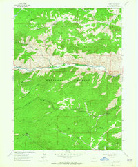
1962 Map of Rustic
USGS Topo · Published 1965About this map
Manhattan (Site) and its neighboring prospect point to the early mining and ranching legacy along the northern reaches of the Roosevelt National Forest during the mid-twentieth century. The Cache La Poudre River serves as the central artery for this landscape, supporting small settlements like Rustic and Glen Echo while carving through steep terrain near Indian Meadows. Higher elevations are defined by peaks like Prohibition Mountain and the expansive Pingree Hill, where a network of primitive routes including the Manhattan Trail and Crown Point Road provided access to isolated homesteads and high-country parks like Wintersteen Park. Human activity is further evidenced by institutional landmarks such as the Elkhorn School and Lidderdale Canyon Chapel, alongside recreational sites like the Ben Delatour Scout Camp and the Bennett Creek Picnic Area. The map documents a period of transitioning land use, where established ranches like Rockwell Ranch existed alongside developing forest management and outdoor education facilities.
Find a feature on this map
41 named features on this map. Tap any name to fly to it.
Don’t see what you’re looking for? This feature index may not catch every label — zoom into the map to look around manually.
Map Details
Editions of this 1962 Rustic Map
2 editions found
Other maps of this area

1907 · Livermore
USGS Topo · 1:125,000

1909 · Livermore
USGS Topo · 1:125,000

1916 · Home
USGS Topo · 1:125,000

1920 · Home
USGS Topo · 1:125,000

1954 · Greeley
USGS Topo · 1:250,000

1957 · Greeley
USGS Topo · 1:250,000

1958 · Greeley
USGS Topo · 1:250,000

1960 · Haystack Gulch
USGS Topo · 1:24,000

1961 · Greeley
USGS Topo · 1:250,000
1962 · Pingree Park
USGS Topo · 1:24,000