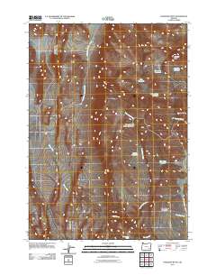
2011 Map of Ryegrass Butte
USGS Topo · Published 2011About this map
Ryegrass Butte rises above an arid landscape of Malheur County, where water management is the primary human imprint on the land. In this 2011 survey, a complex network of small catchments and drainages like North Heath Creek and Sheepshead Canyon Creek feed into a series of functional water bodies. These include Lake Edge Reservoir, Gabriel Reservoir, and the curiously named Euglena Reservoir. The terrain is defined by the Sheepshead Mountains and local landmarks such as Small Butte, emphasizing the isolation of this high desert region. Cattle ranching and land use are evidenced by the placement of the Upper Hole Reservoir and Inbetween Reservoir, while the presence of Heath Creek Spring marks a rare natural water source in this dry volcanic environment.
Find a feature on this map
18 named features on this map. Tap any name to fly to it.
Don’t see what you’re looking for? This feature index may not catch every label — zoom into the map to look around manually.
Map Details
Editions of this 2011 Ryegrass Butte Map
This is the sole edition of this map. No revisions or reprints were ever made.
Other maps of this area

1955 · Burns
USGS Topo · 1:250,000

1955 · Adel
USGS Topo · 1:250,000

1957 · Adel
USGS Topo · 1:250,000

1958 · Burns
USGS Topo · 1:250,000

1958 · Adel
USGS Topo · 1:250,000

1959 · Burns
USGS Topo · 1:250,000

1962 · Adel
USGS Topo · 1:250,000

1974 · Anderson Mtn
USGS Topo · 1:62,500
1974 · Turnbull Peak
USGS Topo · 1:24,000
1974 · Folly Farm
USGS Topo · 1:24,000