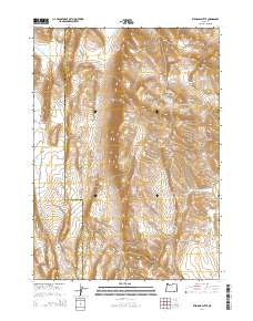
2014 Map of Ryegrass Butte
USGS Topo · Published 2014About this map
Sheepshead Mountains terrain dominates this high-desert landscape along the border of Harney and Malheur counties. The area is defined by a complex network of seasonal water management and natural springs, indicating its importance for regional livestock and wildlife. Small catchments like Inbetween Reservoir, Capp Reservoir, and Gabriel Reservoir are scattered throughout the draws and canyons, including Renwick Canyon. The southern portion of the quadrangle is anchored by the Wildhorse Spring Number One, Wildhorse Spring Number Two, and Wildhorse Spring Number Three cluster near Palomino Cr. This 2014 survey documents the topographical prominence of Ryegrass Butte and Small Butte, providing a detailed look at the water-scarce environment of Eastern Oregon where every named spring and reservoir represents a vital resource for the land.
Find a feature on this map
24 named features on this map. Tap any name to fly to it.
Don’t see what you’re looking for? This feature index may not catch every label — zoom into the map to look around manually.
Map Details
Editions of this 2014 Ryegrass Butte Map
This is the sole edition of this map. No revisions or reprints were ever made.
Other maps of this area

1955 · Burns
USGS Topo · 1:250,000

1955 · Adel
USGS Topo · 1:250,000

1957 · Adel
USGS Topo · 1:250,000

1958 · Burns
USGS Topo · 1:250,000

1958 · Adel
USGS Topo · 1:250,000

1959 · Burns
USGS Topo · 1:250,000

1962 · Adel
USGS Topo · 1:250,000

1974 · Anderson Mtn
USGS Topo · 1:62,500
1974 · Turnbull Peak
USGS Topo · 1:24,000
1974 · Folly Farm
USGS Topo · 1:24,000