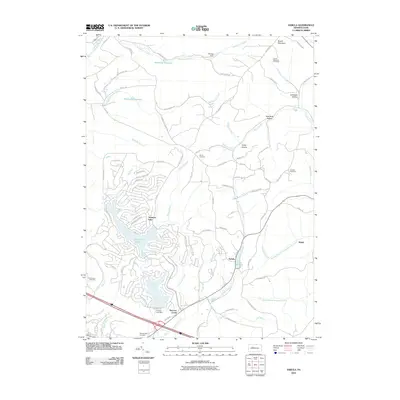
2010 Map of Sabula
USGS Topo · Published 2010About this map
Treasure Lake and the surrounding resort community dominate the western landscape of this 2010 survey, while the village of Sabula sits to the east near the shores of Lake Sabula. The terrain is defined by the high elevations of Boone Mountain, featuring the Boone Mountain Fire Tower and several deep hollows like Lambskin Hollow and Pete Buck Hollow. Water management is a central theme of the area, evidenced by infrastructure like the Storage Dam on Whetstone Branch, the Brockway Reservoir, and the Gravel Lick Dam near Narrows Creek. Local history and genealogy are anchored by several named burial sites, including Bundy Cemetery near the old Bundy Settlement Rd and Conway Cemetery to the east. The map captures a mix of modern residential development and traditional rural mountain geography, with a dense network of local roads winding through the valley of Sandy Lick Creek.
Find a feature on this map
93 named features on this map. Tap any name to fly to it.
Don’t see what you’re looking for? This feature index may not catch every label — zoom into the map to look around manually.
Map Details
Editions of this 2010 Sabula Map
This is the sole edition of this map. No revisions or reprints were ever made.
Other maps of this area

1922 · Du Bois
USGS Topo · 1:62,500

1924 · Du Bois
USGS Topo · 1:62,500

1929 · Penfield
USGS Topo · 1:62,500

1932 · Penfield
USGS Topo · 1:62,500

1940 · Hallton
USGS Topo · 1:48,000

1941 · Ridgway
USGS Topo · 1:62,500

1943 · Hallton
USGS Topo · 1:62,500

1944 · Du Bois
USGS Topo · 1:62,500

1944 · Ridgway
USGS Topo · 1:62,500

1957 · Warren
USGS Topo · 1:250,000