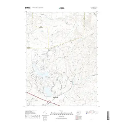
2019 Map of Sabula
USGS Topo · Published 2019About this map
Treasure Lake and its intricate network of waterfront residential roads dominate the western half of this landscape, illustrating the late-20th-century transition of the Pennsylvania wilds into a planned recreation and resort community. This development stands in contrast to the rural, dispersed settlements of Sabula and Walsh to the east. The terrain is defined by the high ridges of Boone Mtn and the deep cut of Lambskin Hollow, with numerous family-named landmarks such as the Heath Homestead Cem and Bundy Cem marking the generational history of the area.
Find a feature on this map
146 named features on this map. Tap any name to fly to it.
Don’t see what you’re looking for? This feature index may not catch every label — zoom into the map to look around manually.
Map Details
Editions of this 2019 Sabula Map
This is the sole edition of this map. No revisions or reprints were ever made.
Other maps of this area

1922 · Du Bois
USGS Topo · 1:62,500

1924 · Du Bois
USGS Topo · 1:62,500

1929 · Penfield
USGS Topo · 1:62,500

1932 · Penfield
USGS Topo · 1:62,500

1940 · Hallton
USGS Topo · 1:48,000

1941 · Ridgway
USGS Topo · 1:62,500

1943 · Hallton
USGS Topo · 1:62,500

1944 · Du Bois
USGS Topo · 1:62,500

1944 · Ridgway
USGS Topo · 1:62,500

1957 · Warren
USGS Topo · 1:250,000