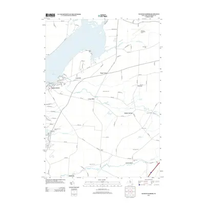
2013 Map of Sackets Harbor
USGS Topo · Published 2013About this map
Sackets Harbor serves as the focal point for this survey along the eastern shores of Lake Ontario, where Lake Ontario meets the mouth of Mill Cr. The village's maritime and military heritage is evident through features like the Sackets Harbor Town Dock, the Sackets Harbor Light, and the nearby Military Cem. To the east, the landscape transitions into a network of small agricultural and rural crossroads such as Jewettville, Baggs Corner, and Sulphur Springs. Further inland, the presence of the Watertown International Airport at the northern edge contrasts with the more traditional rural patterns found near Smithville and North Adams to the south. Numerous small streams, including Muskellunge Cr and Stony Cr, drain the terrain toward the lake, while established family-named landmarks like Reed Haven Farms and Valley Stock Farm reflect the ongoing agricultural character of Jefferson County in the early 21st century.
Find a feature on this map
98 named features on this map. Tap any name to fly to it.
Don’t see what you’re looking for? This feature index may not catch every label — zoom into the map to look around manually.
Map Details
Editions of this 2013 Sackets Harbor Map
This is the sole edition of this map. No revisions or reprints were ever made.
Other maps of this area

1893 · Sackets Harbor
USGS Topo · 1:62,500

1895 · Sacketts Harbor
USGS Topo · 1:62,500

1895 · Watertown
USGS Topo · 1:62,500

1898 · Watertown
USGS Topo · 1:62,500

1900 · Clayton
USGS Topo · 1:62,500

1903 · Clayton
USGS Topo · 1:62,500

1903 · Theresa
USGS Topo · 1:62,500

1908 · Watertown
USGS Topo · 1:62,500

1909 · Watertown
USGS Topo · 1:62,500

1942 · Henderson Bay
USGS Topo · 1:31,680