
Loading...
Loading map...2023 Map of Sackets Harbor
USGS Topo · Published 2023About this map
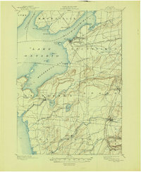
Sackets Harbor serves as the focal point of this coastal landscape, situated where the Black River Bay meets Lake Ontario. The shoreline is defined by prominent landforms such as Pillar Point and Navy Point, reflecting the strategic maritime positioning that has shaped this region since the early 19th century. Inland, the map reveals a mosaic of small settlements and agricultural crossings, including Jewettville, Baggs Corner, and Sulphur Springs.
Find a feature on this map
93 named features on this map. Tap any name to fly to it.
Don’t see what you’re looking for? This feature index may not catch every label — zoom into the map to look around manually.
Map Details
Date Portrayed2023
Date Published2023
PublisherU.S. Geological Survey
Map TypeTopographic
Scale1:24000
Physical Dimensions24 x 29 inches
Editions of this 2023 Sackets Harbor Map
This is the sole edition of this map. No revisions or reprints were ever made.
Historical Maps of Adams Center Through Time
5 maps found

Featured Locations
Source Details
SourceU.S. Geological Survey
CopyrightPublic Domain