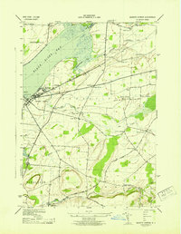
1943 Map of Sackets Harbor
USGS Topo · Published 1943About this map
Madison Barracks and the U S Naval Sta anchor the shoreline of this 1940s wartime survey, overlooking the strategic waters where Black River Bay meets the eastern edge of Lake Ontario. This era was a period of significant military and civil aviation activity, marked by the presence of the Watertown Municipal Airport and its accompanying Airway Beacon. The landscape is defined by the transition from maritime installations at Navy Pt to the inland agricultural and transport network of the town of Hounsfield.
Find a feature on this map
40 named features on this map. Tap any name to fly to it.
Don’t see what you’re looking for? This feature index may not catch every label — zoom into the map to look around manually.
Map Details
Editions of this 1943 Sackets Harbor Map
This is the sole edition of this map. No revisions or reprints were ever made.
Other maps of this area

1893 · Sackets Harbor
USGS Topo · 1:62,500

1895 · Sacketts Harbor
USGS Topo · 1:62,500

1895 · Watertown
USGS Topo · 1:62,500

1898 · Watertown
USGS Topo · 1:62,500

1900 · Clayton
USGS Topo · 1:62,500

1903 · Clayton
USGS Topo · 1:62,500

1903 · Theresa
USGS Topo · 1:62,500

1908 · Watertown
USGS Topo · 1:62,500

1909 · Watertown
USGS Topo · 1:62,500

1942 · Henderson Bay
USGS Topo · 1:31,680