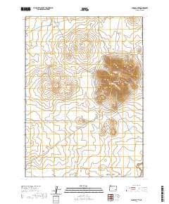
2020 Map of Saddle Butte
USGS Topo · Published 2020About this map
Saddle Butte dominates this high desert landscape, standing as a prominent landmark amidst the extensive volcanic terrain of the Saddle Butte Lava Field. This southeastern Oregon territory in Malheur County is defined by its sparse water sources and immense volcanic features, with drainage provided by ephemeral waterways like Bull Cr to the north and Ryegrass Cr in the south. The mapping reflects the enduring survey grid of the Public Land Survey System, including portions of T28S R39E and T29S R39E. Remote access is primarily represented by Iron Mountain Rd in the southwestern corner, suggesting a landscape mostly utilized for rangeland or geological study rather than dense settlement. The topographic detail highlights the unique volcanic morphology of the butte and its surrounding basaltic flows, providing a precise record of this high-elevation basalt field.
Find a feature on this map
11 named features on this map. Tap any name to fly to it.
Don’t see what you’re looking for? This feature index may not catch every label — zoom into the map to look around manually.
Map Details
Editions of this 2020 Saddle Butte Map
This is the sole edition of this map. No revisions or reprints were ever made.
Other maps of this area

1955 · Jordan Valley
USGS Topo · 1:250,000

1955 · Burns
USGS Topo · 1:250,000

1955 · Adel
USGS Topo · 1:250,000

1955 · Boise
USGS Topo · 1:250,000

1957 · Adel
USGS Topo · 1:250,000

1957 · Jordan Valley
USGS Topo · 1:250,000

1958 · Burns
USGS Topo · 1:250,000

1958 · Boise
USGS Topo · 1:250,000

1958 · Adel
USGS Topo · 1:250,000

1958 · Jordan Valley
USGS Topo · 1:250,000