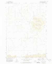
1972 Map of Saddle Butte
USGS Topo · Published 1975About this map
Saddle Butte rises as the dominant landform in this high-desert landscape, defining the topography of Malheur County. The map documents a volcanic terrain characterized by the Saddle Butte Lava Field at the southern edge, illustrating the expansive reach of past basaltic flows. In this arid environment, water remains a critical and sparse feature, represented by the ephemeral courses of Bull Creek and Ryegrass Creek. Traces of rangeland activity and geological exploration are evident in the inclusion of a Corral and a Drill Hole, reflecting the intersection of traditional cattle ranching and modern resource surveying. The detailed contour lines reveal the distinct peak of Saddle 5286, providing a clear view of the elevation changes that have historically influenced movement and land use in this part of southeastern Oregon.
Find a feature on this map
7 named features on this map. Tap any name to fly to it.
Don’t see what you’re looking for? This feature index may not catch every label — zoom into the map to look around manually.
Map Details
Editions of this 1972 Saddle Butte Map
This is the sole edition of this map. No revisions or reprints were ever made.
Other maps of this area

1955 · Jordan Valley
USGS Topo · 1:250,000

1955 · Burns
USGS Topo · 1:250,000

1955 · Adel
USGS Topo · 1:250,000

1955 · Boise
USGS Topo · 1:250,000

1957 · Adel
USGS Topo · 1:250,000

1957 · Jordan Valley
USGS Topo · 1:250,000

1958 · Burns
USGS Topo · 1:250,000

1958 · Boise
USGS Topo · 1:250,000

1958 · Adel
USGS Topo · 1:250,000

1958 · Jordan Valley
USGS Topo · 1:250,000