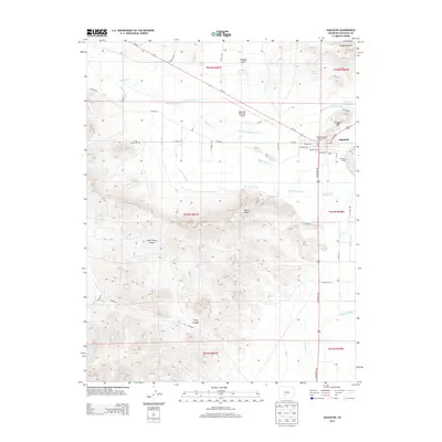
2013 Map of Saguache
USGS Topo · Published 2013About this map
Saguache serves as a central hub at the edge of the valley, where the San Luis Valley floor meets the rising peaks of the San Juan Mountains. This 2013 survey reveals an intricate network of water management features essential to the region's agricultural heritage, including the Rio Grande Canal, Big Meadow Ditch, and the Lawrence Ditch. These waterways parallel Saguache Creek and the Werner Arroyo, illustrating how early settlers and modern ranchers harnessed limited water resources to sustain the arid landscape. The map highlights key community landmarks such as the Saguache District Ranger Office and the Saguache Municipal Airport. For those researching local history, the placement of the Campo Santo Cem and Hillside Cem provide clear points of interest. The terrain rises sharply to the south and west into high-altitude features like Devils Knob and North Tracy Canyon, while Flagpole Hill overlooks the town site from the northeast.
Find a feature on this map
49 named features on this map. Tap any name to fly to it.
Don’t see what you’re looking for? This feature index may not catch every label — zoom into the map to look around manually.
Map Details
Editions of this 2013 Saguache Map
This is the sole edition of this map. No revisions or reprints were ever made.
Other maps of this area

1915 · Del Norte
USGS Topo · 1:125,000

1917 · Del Norte
USGS Topo · 1:125,000

1945 · Durango
USGS Topo · 1:250,000

1953 · Durango
USGS Topo · 1:250,000

1954 · Durango
USGS Topo · 1:250,000

1956 · Montrose
USGS Topo · 1:250,000

1959 · Montrose
USGS Topo · 1:250,000

1960 · Montrose
USGS Topo · 1:250,000

1961 · Durango
USGS Topo · 1:250,000

1963 · Durango
USGS Topo · 1:250,000