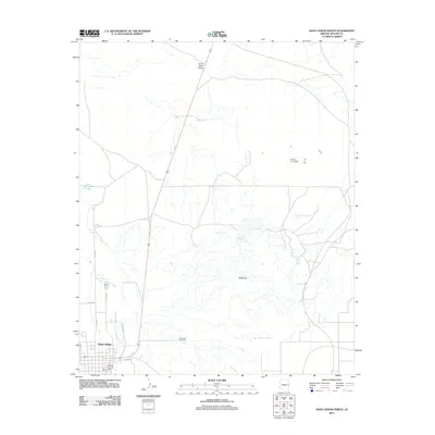
2011 Map of Saint Johns North
USGS Topo · Published 2011About this map
Saint Johns serves as the primary focal point of this northern Apache County survey, situated along the course of the Little Colorado River. The landscape is characterized by a mix of hydrological management and natural erosion, with the expansive Coronado Evaporation Reservoir and smaller water sources like Sorenson Lake, Deep Lake Tank, and Alejandro Tank dotting the arid terrain. The eastern edge of the settlement includes the East Side Cemetery, a significant site for local genealogical research. Further east, the terrain transitions into the distinctive Badlands, where drainage patterns from features like McIntosh Spring feed into the river system. Transportation infrastructure is marked by the Carrizo Wash Bridge to the north and a grid of local roads including Jefferson St and N Water St that define the community's northern expansion during this era.
Find a feature on this map
17 named features on this map. Tap any name to fly to it.
Don’t see what you’re looking for? This feature index may not catch every label — zoom into the map to look around manually.
Map Details
Editions of this 2011 Saint Johns North Map
This is the sole edition of this map. No revisions or reprints were ever made.
Other maps of this area

1886 · St Johns
USGS Topo · 1:250,000

1892 · St Johns
USGS Topo · 1:250,000

1954 · Saint Johns
USGS Topo · 1:250,000

1955 · Wolford Springs 3 NW
USGS Topo · 1:24,000

1955 · Wolford Springs 3 SW
USGS Topo · 1:24,000

1957 · Saint Johns
USGS Topo · 1:250,000

1958 · Saint Johns
USGS Topo · 1:250,000

1962 · Saint Johns
USGS Topo · 1:250,000

1971 · Mesa Parada NW
USGS Topo · 1:24,000
1971 · Salado
USGS Topo · 1:24,000