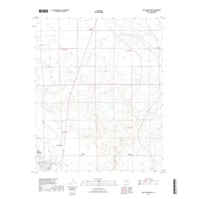
2018 Map of Saint Johns North
USGS Topo · Published 2018About this map
St. Johns serves as the primary hub in this arid high-desert landscape of eastern Arizona, situated where the Little Colorado River winds through the southwestern corner of the quadrangle. The town's grid extends toward the St Johns Industrial Air Park, while the surrounding terrain is defined by dry washes and essential water management features. To the east, the Saint Johns Catholic Cem provides a point of significant genealogical interest. Beyond the settlement, the landscape is marked by a network of drainage features like Carrizo Wash, which is spanned by the Carrizo Wash Bridge in the north. The presence of McIntosh Spring and various livestock tanks, including Alejandro Tank and Deep Lake Tank, highlights the critical role of water sourcing in this ranching country. The topography is further etched by named natural features such as Marion Haws Draw and the shoreline of Sorenson Lake.
Find a feature on this map
29 named features on this map. Tap any name to fly to it.
Don’t see what you’re looking for? This feature index may not catch every label — zoom into the map to look around manually.
Map Details
Editions of this 2018 Saint Johns North Map
This is the sole edition of this map. No revisions or reprints were ever made.
Other maps of this area

1886 · St Johns
USGS Topo · 1:250,000

1892 · St Johns
USGS Topo · 1:250,000

1954 · Saint Johns
USGS Topo · 1:250,000

1955 · Wolford Springs 3 NW
USGS Topo · 1:24,000

1955 · Wolford Springs 3 SW
USGS Topo · 1:24,000

1957 · Saint Johns
USGS Topo · 1:250,000

1958 · Saint Johns
USGS Topo · 1:250,000

1962 · Saint Johns
USGS Topo · 1:250,000

1971 · Mesa Parada NW
USGS Topo · 1:24,000
1971 · Salado
USGS Topo · 1:24,000