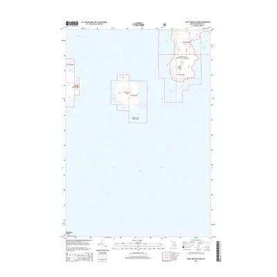
2014 Map of Saint Martin Island
USGS Topo · Published 2014About this map
Saint Martin Island and its surrounding archipelago dominate this maritime survey of the northern waters of Lake Huron. The cluster includes Big Saint Martin Island, known for its distinctive hook-shaped southern shoreline, and the smaller Little Saint Martin Island to the southeast. Much of the land area on the larger island is managed as part of the Hiawatha National Forest, which also encompasses the mainland region around Paquin Lake and the prominent Saint Martin Point. The geography here defines the transition between Saint Martin Bay and Search Bay, providing a clear look at the coastal contours and isolated landmasses north of Mackinac Island. This 2014 edition captures the shoreline and forest boundaries as they existed in the early 21st century, detailing the township and range divisions across this remote corner of Mackinac County.
Find a feature on this map
12 named features on this map. Tap any name to fly to it.
Don’t see what you’re looking for? This feature index may not catch every label — zoom into the map to look around manually.
Map Details
Editions of this 2014 Saint Martin Island Map
This is the sole edition of this map. No revisions or reprints were ever made.
Other maps of this area

1931 · St Ignace NW
USGS Topo · 1:31,680

1932 · St Ignace NE
USGS Topo · 1:31,680

1954 · Sault Sainte Marie
USGS Topo · 1:250,000

1955 · Cheboygan
USGS Topo · 1:250,000

1956 · Sault Sainte Marie
USGS Topo · 1:250,000

1957 · Sault Sainte Marie
USGS Topo · 1:250,000

1958 · Cheboygan
USGS Topo · 1:250,000

1958 · Sault Sainte Marie
USGS Topo · 1:250,000

1964 · Round Island
USGS Topo · 1:24,000
1964 · Evergreen Shores
USGS Topo · 1:24,000