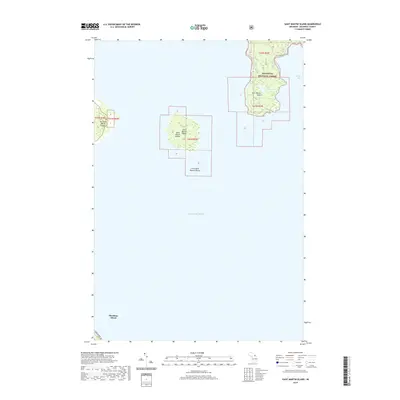
2019 Map of Saint Martin Island
USGS Topo · Published 2019About this map
Lake Huron surrounds a cluster of northern islands in this recent survey of the straits region. The Saint Martin Islands group, including Big Saint Martin Island, Saint Martin Island, and Little Saint Martin Island, sits centrally within the shipping lanes. To the north, the mainland portion of the Hiawatha National Forest extends down to Saint Martin Point, framing the western edge of Search Bay. This area remains largely defined by its natural topography and protected forest lands, with Paquin Lake situated in the interior of the northern peninsula. Along the southern edge of the map, a portion of Mackinac Island is visible, featuring the iconic Lake Shore Dr skirting the coastline. The map illustrates the geographical relationship between these detached island landmasses and the mainland forest during the late twenty-teens.
Find a feature on this map
14 named features on this map. Tap any name to fly to it.
Don’t see what you’re looking for? This feature index may not catch every label — zoom into the map to look around manually.
Map Details
Editions of this 2019 Saint Martin Island Map
This is the sole edition of this map. No revisions or reprints were ever made.
Other maps of this area

1931 · St Ignace NW
USGS Topo · 1:31,680

1932 · St Ignace NE
USGS Topo · 1:31,680

1954 · Sault Sainte Marie
USGS Topo · 1:250,000

1955 · Cheboygan
USGS Topo · 1:250,000

1956 · Sault Sainte Marie
USGS Topo · 1:250,000

1957 · Sault Sainte Marie
USGS Topo · 1:250,000

1958 · Cheboygan
USGS Topo · 1:250,000

1958 · Sault Sainte Marie
USGS Topo · 1:250,000

1964 · Round Island
USGS Topo · 1:24,000
1964 · Evergreen Shores
USGS Topo · 1:24,000