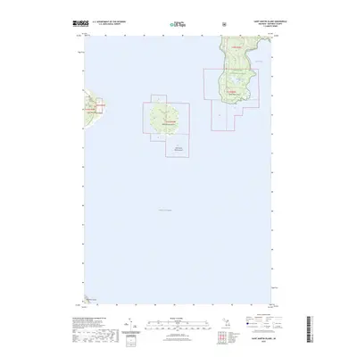
2023 Map of Saint Martin Island
USGS Topo · Published 2023About this map
Hiawatha National Forest dominates the northern reaches of this archipelago within Lake Huron, where the shoreline of Saint Martin Point defines the southern tip of the mainland projection. This modern survey details the isolated island geography of the Saint Martin group, specifically highlighting Big Saint Martin Island and its smaller counterpart, Little Saint Martin Island. A significant historical landmark, the Indian Burial Ground, is noted on the western coast of the larger island, providing a crucial point of reference for genealogists and local historians. The map also captures the interior hydrology of the peninsula, such as Paquin Lake, and the eastern waters of Search Bay, while the northernmost edge of Mackinac Island appears at the bottom margin, illustrating the strategic maritime proximity between these landmasses.
Find a feature on this map
13 named features on this map. Tap any name to fly to it.
Don’t see what you’re looking for? This feature index may not catch every label — zoom into the map to look around manually.
Map Details
Editions of this 2023 Saint Martin Island Map
This is the sole edition of this map. No revisions or reprints were ever made.
Other maps of this area

1931 · St Ignace NW
USGS Topo · 1:31,680

1932 · St Ignace NE
USGS Topo · 1:31,680

1954 · Sault Sainte Marie
USGS Topo · 1:250,000

1955 · Cheboygan
USGS Topo · 1:250,000

1956 · Sault Sainte Marie
USGS Topo · 1:250,000

1957 · Sault Sainte Marie
USGS Topo · 1:250,000

1958 · Cheboygan
USGS Topo · 1:250,000

1958 · Sault Sainte Marie
USGS Topo · 1:250,000

1964 · Round Island
USGS Topo · 1:24,000
1964 · Evergreen Shores
USGS Topo · 1:24,000