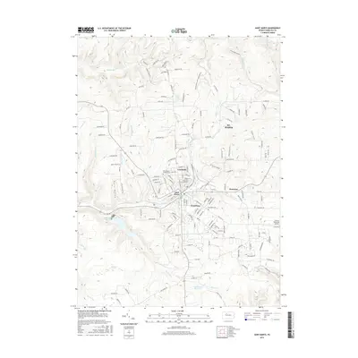
2016 Map of Saint Marys
USGS Topo · Published 2016About this map
St. Marys and its surrounding neighborhoods of Lynchville and Kaulmont occupy the center of this Elk County landscape. The topography is defined by the winding valley of Elk Creek and numerous tributary runs, such as Water Tank Run and Vincent Run, which carve through the high ground of Hawk Ridge. Local history is anchored at the Saint Mary's Catholic Cemetery, while the modern connectivity of the region is represented by the St Marys Municipal Airport to the east. To the south, the terrain becomes increasingly complex around the Laurel Run Reservoir and the wetlands of Balsam Swamp. The map details a dense network of forest roads, including the Pennsylvania Game Commission Road and several family-named routes, illustrating the intersection of residential life and the surrounding timbered highlands.
Find a feature on this map
156 named features on this map. Tap any name to fly to it.
Don’t see what you’re looking for? This feature index may not catch every label — zoom into the map to look around manually.
Map Details
Editions of this 2016 Saint Marys Map
This is the sole edition of this map. No revisions or reprints were ever made.
Other maps of this area

1935 · Mt. Jewett
USGS Topo · 1:48,000

1940 · Mt. Jewett
USGS Topo · 1:62,500

1941 · Benezette
USGS Topo · 1:62,500

1941 · Ridgway
USGS Topo · 1:62,500

1943 · Benezette
USGS Topo · 1:62,500

1944 · Ridgway
USGS Topo · 1:62,500

1948 · Crosby
USGS Topo · 1:62,500

1948 · Wildwood Fire Tower
USGS Topo · 1:24,000
1950 · Wildwood Fire Tower
USGS Topo · 1:24,000

1957 · Warren
USGS Topo · 1:250,000