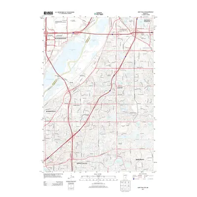
2013 Map of Saint Paul SW
USGS Topo · Published 2013About this map
Long Meadow Lake and the winding Minnesota River form a wide natural boundary between Bloomington in Hennepin County and the rising suburbs of Dakota County. This modern landscape shows the dense infrastructure supporting the southern Twin Cities, from the southern edge of the Minneapolis-St Paul International/Wold-Chamberlain Airport to the sprawling residential developments in Eagan, Burnsville, and Apple Valley. Smaller historical nodes like Nicols and Cedar Grove sit near major transit corridors, while the Cedar Avenue Bridge connects the two counties across the river flats. The area is dotted with significant institutional sites, including several colleges and the expansive Ft Snelling National Cemetery in the north, contrasting with the many smaller bodies of water like Blackhawk Lake and Quigley Lake that define the local topography.
Find a feature on this map
99 named features on this map. Tap any name to fly to it.
Don’t see what you’re looking for? This feature index may not catch every label — zoom into the map to look around manually.
Map Details
Editions of this 2013 Saint Paul SW Map
This is the sole edition of this map. No revisions or reprints were ever made.
Other maps of this area

1896 · Minneapolis
USGS Topo · 1:62,500

1896 · St. Paul
USGS Topo · 1:62,500

1901 · Minneapolis
USGS Topo · 1:62,500

1951 · St. Paul West
USGS Topo · 1:24,000

1951 · Inver Grove
USGS Topo · 1:24,000

1951 · St. Paul SW
USGS Topo · 1:24,000

1951 · St. Paul East
USGS Topo · 1:24,000

1951 · St. Paul
USGS Topo · 1:62,500

1952 · Minneapolis South
USGS Topo · 1:24,000

1953 · Saint Paul
USGS Topo · 1:250,000