
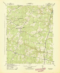
1943 Map of Salem Church
USGS Topo · Published 1961About this map
The Rappahannock River winds through the heart of this landscape, marking the boundary between Stafford and Spotsylvania counties. In the years during the Second World War, this region remained predominantly rural, characterized by small hilltop settlements and a network of country roads connecting local landmarks. The area around Chancellor and Five Mile Fork is punctuated by significant local institutions, including Salem Ch, Tabernacle Ch, and Chancellor Sch. The terrain is heavily dissected by numerous watercourses such as Ninemile Run and Motts Run, which feed into the primary river systems. These topographic details reveal a pre-suburban era of Central Virginia, where the placement of schools like Diggs Sch and various small churches served as the primary social anchors for a scattered farming community before modern expansion altered the footprint of the countryside.
Find a feature on this map
31 named features on this map. Tap any name to fly to it.
Don’t see what you’re looking for? This feature index may not catch every label — zoom into the map to look around manually.
Map Details
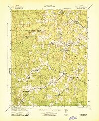
Editions of this 1943 Salem Church Map
This is the sole edition of this map. No revisions or reprints were ever made.
Other maps of this area

1887 · Spottsylvania
USGS Topo · 1:125,000

1889 · Fredericksburg
USGS Topo · 1:125,000

1892 · Fredericksburg
USGS Topo · 1:125,000

1892 · Spottsylvania
USGS Topo · 1:125,000

1894 · Fredericksburg
USGS Topo · 1:125,000

1926 · Stafford
USGS Topo · 1:62,500

1931 · Stafford
USGS Topo · 1:62,500

1942 · Guinea
USGS Topo · 1:31,680
1942 · Spotsylania
USGS Topo · 1:31,680
1942 · Brokenburg
USGS Topo · 1:31,680