
1942 Map of Brokenburg
USGS Topo · Published 1942About this map
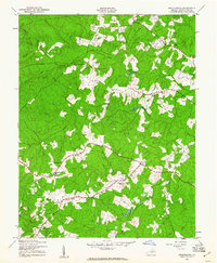
The unincorporated crossroads of Brokenburg and the surrounding Spotsylvania County countryside were captured in detail by the War Department just as the United States entered the second year of World War II. This 1942 landscape is defined by its rural community centers, featuring a concentration of churches including Hebron Church, Lebanon Church, and Mine Road Church, alongside the Spotsylvania Camp Meeting grounds to the north.
Find a feature on this map
30 named features on this map. Tap any name to fly to it.
Don’t see what you’re looking for? This feature index may not catch every label — zoom into the map to look around manually.
Map Details
Editions of this 1942 Brokenburg Map
2 editions found
Other maps of this area

1887 · Spottsylvania
USGS Topo · 1:125,000

1892 · Spottsylvania
USGS Topo · 1:125,000

1942 · Ladysmith
USGS Topo · 1:31,680

1942 · Partlow
USGS Topo · 1:31,680

1942 · Belmont
USGS Topo · 1:31,680

1942 · Contrary Creek
USGS Topo · 1:31,680

1942 · Spotsylania
USGS Topo · 1:31,680

1943 · Chancellorsville
USGS Topo · 1:24,000

1943 · Salem Church
USGS Topo · 1:24,000

1943 · Mine Run
USGS Topo · 1:24,000