
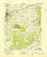
1943 Map of Mine Run
USGS Topo · Published 1961About this map
The Rapidan River forms the northern boundary of this landscape, winding through a region where Orange, Culpeper, and Spotsylvania counties meet. In the early 1940s, the area is defined by a network of rural settlements and crossroads including Locustgrove, Golddale, and the namesake Mine Run. Local life centers around a scattering of rural institutions such as Mt Zion Ch, New Hope Ch, and Zoar Sch. A significant portion of the eastern terrain is occupied by the Wilderness National Military Park, preserving the site of major Civil War maneuvers. The map details an intricate drainage system with named watercourses like Mountain Run, Cormack Run, and Strawberry Branch, showing how the topography influenced the placement of early homesteads and small communities like Indiantown and Parker.
Find a feature on this map
29 named features on this map. Tap any name to fly to it.
Don’t see what you’re looking for? This feature index may not catch every label — zoom into the map to look around manually.
Map Details
Editions of this 1943 Mine Run Map
This is the sole edition of this map. No revisions or reprints were ever made.
Other maps of this area

1887 · Spottsylvania
USGS Topo · 1:125,000

1892 · Spottsylvania
USGS Topo · 1:125,000

1942 · Lahore
USGS Topo · 1:31,680

1942 · Belmont
USGS Topo · 1:31,680

1942 · Brokenburg
USGS Topo · 1:31,680

1943 · Germanna Bridge
USGS Topo · 1:24,000

1943 · Chancellorsville
USGS Topo · 1:24,000

1943 · Culpeper
USGS Topo · 1:24,000

1943 · Unionville
USGS Topo · 1:24,000
1944 · Culpeper
USGS Topo · 1:31,680