
1942 Map of Guinea
USGS Topo · Published 1942About this map
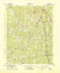
The Richmond Fredericksburg and Potomac railroad forms the central spine of this 1942 landscape, connecting the small rail settlements of Guinea, Summit, and Massaponax Sta. Industrial activity is evident at the A L Clark & Sons (Creosote) plant near the tracks, while the northeastern corner shows early aviation at Nottingham Field along the Rappahannock River.
Find a feature on this map
30 named features on this map. Tap any name to fly to it.
Don’t see what you’re looking for? This feature index may not catch every label — zoom into the map to look around manually.
Map Details
Editions of this 1942 Guinea Map
This is the sole edition of this map. No revisions or reprints were ever made.
Other maps of this area

1887 · Spottsylvania
USGS Topo · 1:125,000

1889 · Fredericksburg
USGS Topo · 1:125,000

1892 · Fredericksburg
USGS Topo · 1:125,000

1892 · Spottsylvania
USGS Topo · 1:125,000

1894 · Fredericksburg
USGS Topo · 1:125,000

1926 · Stafford
USGS Topo · 1:62,500

1931 · Stafford
USGS Topo · 1:62,500

1942 · Bowling Green
USGS Topo · 1:31,680

1942 · Woodford
USGS Topo · 1:31,680
1942 · Ladysmith
USGS Topo · 1:31,680