
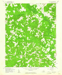
1942 Map of Woodford
USGS Topo · Published 1942About this map
The Mattaponi River and its major tributaries, the Matta River and South River, dominate this 1942 landscape in Caroline County. The Richmond Fredericksburg and Potomac rail line cuts north-to-south through the village of Woodford, serving as a primary transportation artery through this agricultural and timber-producing region. Local community life is anchored by family-named crossroads like Washington Corner, Wrights Corner, and Collins Crossing, while spiritual and social centers include Bethel Church and St John Church.
Find a feature on this map
21 named features on this map. Tap any name to fly to it.
Don’t see what you’re looking for? This feature index may not catch every label — zoom into the map to look around manually.
Map Details
Editions of this 1942 Woodford Map
3 editions found
Other maps of this area

1887 · Spottsylvania
USGS Topo · 1:125,000

1889 · Fredericksburg
USGS Topo · 1:125,000

1890 · Goochland
USGS Topo · 1:125,000

1892 · Fredericksburg
USGS Topo · 1:125,000

1892 · Spottsylvania
USGS Topo · 1:125,000

1892 · Goochland
USGS Topo · 1:125,000

1894 · Fredericksburg
USGS Topo · 1:125,000

1918 · Doswell
USGS Topo · 1:62,500

1942 · Bowling Green
USGS Topo · 1:31,680

1942 · Guinea
USGS Topo · 1:31,680