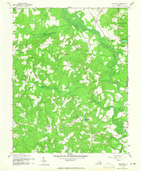
1942 Map of Woodford
USGS Topo · Published 1965About this map
The Mattaponi River and South River converge in this rural landscape of Caroline County, shortly after the start of World War II. The northern portion of the quadrangle is dominated by the A P Hill Military Reservation, signaling the area's wartime importance. Transportation and commerce are anchored by the Richmond Fredericksburg and Potomac railroad corridor, which passes through the village of Woodford.
Find a feature on this map
26 named features on this map. Tap any name to fly to it.
Don’t see what you’re looking for? This feature index may not catch every label — zoom into the map to look around manually.
Map Details
Editions of this 1942 Woodford Map
3 editions found
Other maps of this area

1887 · Spottsylvania
USGS Topo · 1:125,000

1889 · Fredericksburg
USGS Topo · 1:125,000

1890 · Goochland
USGS Topo · 1:125,000

1892 · Fredericksburg
USGS Topo · 1:125,000

1892 · Spottsylvania
USGS Topo · 1:125,000

1892 · Goochland
USGS Topo · 1:125,000

1894 · Fredericksburg
USGS Topo · 1:125,000

1918 · Doswell
USGS Topo · 1:62,500

1942 · Bowling Green
USGS Topo · 1:31,680

1942 · Woodford
USGS Topo · 1:31,680