
1942 Map of Bowling Green
USGS Topo · Published 1942About this map
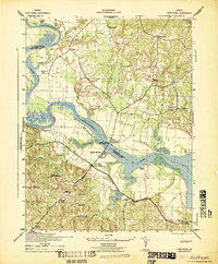
Bowling Green serves as the focal point for this wartime survey of Caroline County, illustrating a landscape transitioning under the requirements of national defense. The northern half of the region is dominated by the A P Hill Military Reservation, with its Reservation Boundary cutting through established agricultural lands and older crossroads. The local economy and infrastructure of the early 1940s are visible through the Richmond Fredericksburg and Potomac railroad line and traditional water-powered sites such as Broaddus Mill and Elliots Mill on Mill Creek.
Find a feature on this map
32 named features on this map. Tap any name to fly to it.
Don’t see what you’re looking for? This feature index may not catch every label — zoom into the map to look around manually.
Map Details
Editions of this 1942 Bowling Green Map
This is the sole edition of this map. No revisions or reprints were ever made.
Other maps of this area

1889 · Fredericksburg
USGS Topo · 1:125,000

1892 · Fredericksburg
USGS Topo · 1:125,000

1894 · Fredericksburg
USGS Topo · 1:125,000

1918 · Doswell
USGS Topo · 1:62,500

1918 · Aylett
USGS Topo · 1:62,500

1933 · Aylett
USGS Topo · 1:62,500

1942 · Upper Zion
USGS Topo · 1:31,680

1942 · Woodford
USGS Topo · 1:31,680

1942 · Guinea
USGS Topo · 1:31,680
1942 · Port Royal
USGS Topo · 1:31,680