
1942 Map of Upper Zion
USGS Topo · Published 1942About this map
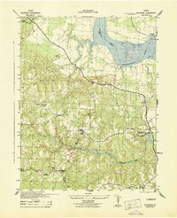
The A P Hill Military Reservation dominates much of this Virginia landscape, illustrating the rapid wartime expansion of military training grounds in 1942. This topographic survey captures the area at a critical juncture where established rural crossroads like Goldmans Corner, Martins Corner, and Jones Corner sat alongside the evolving borders of the reservation. The map reveals a dense network of local landmarks, including Enon Church and Mt Zion Church, which served as anchors for the surrounding agricultural community. Waterways such as Tobacco Creek and Beverly Run provide the natural structure for the terrain, while specific survey points like the USC&GS Naulakla 1941 benchmark indicate the precise geodetic work being performed during the era. The many named junctions, such as Hickory Fork and Liberty Fork, reflect a settlement pattern deeply tied to early road development in Caroline and Essex counties.
Find a feature on this map
24 named features on this map. Tap any name to fly to it.
Don’t see what you’re looking for? This feature index may not catch every label — zoom into the map to look around manually.
Map Details
Editions of this 1942 Upper Zion Map
This is the sole edition of this map. No revisions or reprints were ever made.
Other maps of this area

1889 · Fredericksburg
USGS Topo · 1:125,000

1892 · Fredericksburg
USGS Topo · 1:125,000

1894 · Fredericksburg
USGS Topo · 1:125,000

1918 · Doswell
USGS Topo · 1:62,500

1918 · Aylett
USGS Topo · 1:62,500

1933 · Aylett
USGS Topo · 1:62,500

1942 · Bowling Green
USGS Topo · 1:31,680
1942 · Occupacia
USGS Topo · 1:31,680

1942 · Rollins Fork
USGS Topo · 1:31,680
1942 · Port Royal
USGS Topo · 1:31,680