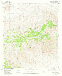
1981 Map of Salinas Peak
USGS Topo · Published 1981About this map
White Sands Missile Range dominates this landscape in Sierra County, reflecting the area's mid-century transition from remote mining and ranching to a restricted military testing ground. The high-desert terrain is marked by the presence of the Salinas Mine and White Mine, which sit tucked into the canyons near White Mine Peak. This 1981 record captures the topography before modern satellite mapping, documenting essential water sources for the region such as Sweetwater Spring, Dolan Spring, and Indian Wells. The rugged geography is defined by steep relief, including the prominent Salinas Peak and the unique formation of Silver Top Mountain. A network of unpaved tracks and jeep trails connects these remote locations, winding through Cottonwood Canyon and along Good Fortune Creek.
Find a feature on this map
49 named features on this map. Tap any name to fly to it.
Don’t see what you’re looking for? This feature index may not catch every label — zoom into the map to look around manually.
Map Details
Editions of this 1981 Salinas Peak Map
This is the sole edition of this map. No revisions or reprints were ever made.
Other maps of this area

1916 · Salinas Peak
USGS Topo · 1:125,000

1916 · Tularosa
USGS Topo · 1:125,000

1947 · Capitol Peak
USGS Topo · 1:62,500

1948 · Black Top Mountain
USGS Topo · 1:62,500

1948 · Salinas Peak
USGS Topo · 1:62,500

1948 · Lumley Lake
USGS Topo · 1:62,500

1954 · Tularosa
USGS Topo · 1:250,000

1958 · Tularosa
USGS Topo · 1:250,000

1981 · Big Gyp Mountain
USGS Topo · 1:24,000

1981 · Fairview Mountain
USGS Topo · 1:24,000