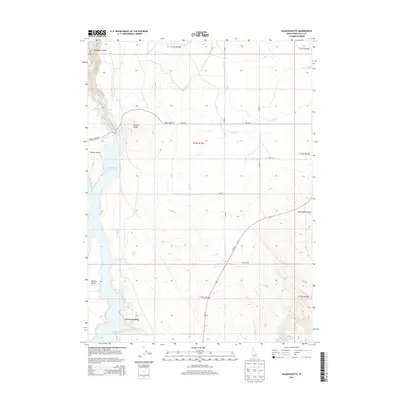
2013 Map of Salmon Butte
USGS Topo · Published 2013About this map
Salmon Falls Creek Reservoir dominates the western edge of this High Desert landscape, where the waters of Salmon Falls Cr are harnessed for the region's agricultural network. The interplay between the arid canyonlands and managed water is evident through features like the Main Canal, A Lateral, and Whiskey Slough. To the east, the terrain rises toward McCongle Canyon, while the prominent volcanic profile of Salmon Butte stands as a landmark above Three Creek Rd. This area reflects the mid-century ranching and irrigation economy of southern Idaho, documented here with points of interest such as Greys Landing and Point Ranch. The map also captures the topography of Browns Bench, a significant plateau overlooking the reservoir, and the path of Us-93 N as it cuts across the high plateau toward the Nevada border.
Find a feature on this map
22 named features on this map. Tap any name to fly to it.
Don’t see what you’re looking for? This feature index may not catch every label — zoom into the map to look around manually.
Map Details
Editions of this 2013 Salmon Butte Map
This is the sole edition of this map. No revisions or reprints were ever made.
Other maps of this area

1955 · Twin Falls
USGS Topo · 1:250,000

1958 · Twin Falls
USGS Topo · 1:250,000

1965 · Hollister SW
USGS Topo · 1:24,000

1965 · Roseworth SE
USGS Topo · 1:24,000

1965 · Hollister
USGS Topo · 1:24,000

1977 · Browns Bench South
USGS Topo · 1:24,000

1977 · Rogerson
USGS Topo · 1:24,000

1977 · Magic Hot Springs
USGS Topo · 1:24,000

1977 · Salmon Butte
USGS Topo · 1:24,000

1978 · Browns Bench North
USGS Topo · 1:24,000