
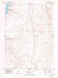
1977 Map of Salmon Butte
USGS Topo · Published 1978About this map
Salmon Falls Dam serves as the focal point of this high-desert landscape, creating the sprawling Salmon Falls Creek Reservoir that dominates the western portion of the terrain. The reservoir's indented shoreline features numerous named inlets such as Antelope Bay, Trout Bay, and Perch Bay, while the elevated ridge of Browns Bench rises to the west. East of the water, the topography is defined by the Union Pacific rail line and a network of irrigation laterals and ranch roads, reflecting the region's agricultural dependency. Evidence of early land use is scattered across the sheet, from the isolated Point Ranch to the specialized Gaging Station and various wells. The map documents a specific balance of infrastructure and natural landmarks, including the prominent Salmon Butte and the sheer Marble Cliff overlooking the water, alongside small commercial or navigational points like Greys Landing.
Find a feature on this map
30 named features on this map. Tap any name to fly to it.
Don’t see what you’re looking for? This feature index may not catch every label — zoom into the map to look around manually.
Map Details
Editions of this 1977 Salmon Butte Map
This is the sole edition of this map. No revisions or reprints were ever made.
Other maps of this area

1955 · Twin Falls
USGS Topo · 1:250,000

1958 · Twin Falls
USGS Topo · 1:250,000

1965 · Hollister SW
USGS Topo · 1:24,000

1965 · Roseworth SE
USGS Topo · 1:24,000

1965 · Hollister
USGS Topo · 1:24,000

1977 · Browns Bench South
USGS Topo · 1:24,000

1977 · Rogerson
USGS Topo · 1:24,000

1977 · Magic Hot Springs
USGS Topo · 1:24,000

1978 · Browns Bench North
USGS Topo · 1:24,000
1978 · Meteor
USGS Topo · 1:24,000