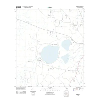
2012 Map of Sampson
USGS Topo · Published 2012About this map
Lake Sampson and its neighboring waters, Lake Crosby and Lake Rowell, dominate this portion of Bradford County. The landscape is defined by the hydrologic connection between these lakes and the Sampson River, which flows westward from the southern shore of its namesake lake. Small rural communities like Sampson and Pleasant Grove are interspersed among a network of county roads and agricultural lands. Several family cemeteries, including Brown Cem, Prescott Cem, and Prevatt Cem, are documented across the terrain, offering significant touchstones for local genealogical research. To the northwest, the Bradford-Union Fire Control Headquarters indicates the region's focus on land management and forestry protection. The map also traces the winding course of Gum Cr and Alligator Cr, illustrating the complex drainage patterns of the north Florida interior.
Find a feature on this map
77 named features on this map. Tap any name to fly to it.
Don’t see what you’re looking for? This feature index may not catch every label — zoom into the map to look around manually.
Map Details
Editions of this 2012 Sampson Map
This is the sole edition of this map. No revisions or reprints were ever made.
Other maps of this area

1918 · Lawtey
USGS Topo · 1:62,500

1941 · Starke
USGS Topo · 1:62,500

1948 · Starke
USGS Topo · 1:50,000

1949 · Sampson
USGS Topo · 1:24,000

1949 · Starke
USGS Topo · 1:24,000

1949 · Waldo
USGS Topo · 1:24,000
1949 · Keystone Heights
USGS Topo · 1:24,000

1949 · Starke
USGS Topo · 1:62,500

1954 · Gainesville
USGS Topo · 1:250,000

1954 · Valdosta
USGS Topo · 1:250,000