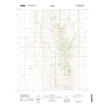
2023 Map of San Andres Peak
USGS Topo · Published 2023About this map
The San Andres Mountains dominate this high-desert landscape, where the rugged peaks and canyons have long been sheltered within the San Andres National Wildlife Refuge. This terrain is characterized by a series of critical water sources that would have been vital for early travelers and ranching, including Goldenburg Springs, Dugout Spring, and the curiously named Chinch-Bug Spring. The eastern portion of the map is defined by the high-elevation summit of San Andres Peak, overlooking the expansive White Sands Missile Range. Significant drainage features like Cottonwood Draw and Lead Camp Canyon show the natural pathways through the mountain range, while man-made water points like Schultz Tank indicate more recent land use and livestock management in this arid environment.
Find a feature on this map
24 named features on this map. Tap any name to fly to it.
Don’t see what you’re looking for? This feature index may not catch every label — zoom into the map to look around manually.
Map Details
Editions of this 2023 San Andres Peak Map
This is the sole edition of this map. No revisions or reprints were ever made.
Other maps of this area

1916 · Tonuco
USGS Topo · 1:125,000

1916 · Point Of Sands
USGS Topo · 1:125,000

1932 · Tonuco
USGS Topo · 1:125,000

1947 · Point Of Sands 2
USGS Topo · 1:62,500

1947 · Lake Lucero
USGS Topo · 1:62,500

1948 · Bear Peak
USGS Topo · 1:62,500

1948 · Kaylor Mountain
USGS Topo · 1:62,500

1948 · Lake Lucero
USGS Topo · 1:24,000

1948 · Lake Lucero SW
USGS Topo · 1:24,000
1950 · Lake Lucero
USGS Topo · 1:24,000