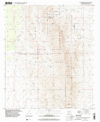
1996 Map of San Andres Peak
USGS Topo · Published 2002About this map
San Andres Peak dominates this high-desert landscape in Doña Ana County, where federal land management and scientific research intersect within the San Andres National Wildlife Refuge. The map illustrates a complex overlay of administrative boundaries, including the White Sands Missile Range and the White Sands Test Facility (NASA). This era of the late 20th century shows the area as a highly restricted zone dedicated to both national defense and ecological preservation.
Find a feature on this map
28 named features on this map. Tap any name to fly to it.
Don’t see what you’re looking for? This feature index may not catch every label — zoom into the map to look around manually.
Map Details
Editions of this 1996 San Andres Peak Map
This is the sole edition of this map. No revisions or reprints were ever made.
Other maps of this area

1916 · Tonuco
USGS Topo · 1:125,000

1916 · Point Of Sands
USGS Topo · 1:125,000

1932 · Tonuco
USGS Topo · 1:125,000

1947 · Point Of Sands 2
USGS Topo · 1:62,500

1947 · Lake Lucero
USGS Topo · 1:62,500

1948 · Bear Peak
USGS Topo · 1:62,500

1948 · Kaylor Mountain
USGS Topo · 1:62,500

1948 · Lake Lucero
USGS Topo · 1:24,000

1948 · Lake Lucero SW
USGS Topo · 1:24,000
1950 · Lake Lucero
USGS Topo · 1:24,000