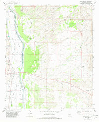
1981 Map of San Antonio
USGS Topo · Published 1982About this map
The Rio Grande valley in Socorro County is defined here by a complex network of irrigation and water management infrastructure, including the Main Conveyance Channel, the Socorro Main Canal, and numerous drains like the Luis Lopez Drain. This desert landscape transitions from the river's fertile edge toward the arid reaches of Walnut Canyon. The village of San Antonio serves as a local hub, situated where the Atchison Topeka and Santa Fe railroad corridor runs parallel to the river.
Find a feature on this map
33 named features on this map. Tap any name to fly to it.
Don’t see what you’re looking for? This feature index may not catch every label — zoom into the map to look around manually.
Map Details
Editions of this 1981 San Antonio Map
This is the sole edition of this map. No revisions or reprints were ever made.
Other maps of this area

1906 · Socorro
USGS Topo · 1:62,500

1916 · La Joya
USGS Topo · 1:125,000

1948 · Carthage
USGS Topo · 1:62,500

1948 · San Antonio
USGS Topo · 1:62,500

1954 · Tularosa
USGS Topo · 1:250,000

1954 · Socorro
USGS Topo · 1:250,000

1958 · Socorro
USGS Topo · 1:250,000

1958 · Tularosa
USGS Topo · 1:250,000

1959 · Loma De Las Canas
USGS Topo · 1:24,000

1959 · Socorro
USGS Topo · 1:24,000