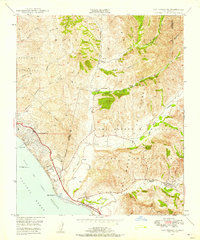
1948 Map of San Clemente
USGS Topo · Published 1958About this map
The coastal transition of the post-war California shoreline is captured here, centered on the growing town of San Clemente and the expansive military presence to the south. The map illustrates the town's early grid and its relationship with the San Clemente Pier, while the rugged interior of the Mission Viejo and Las Flores land grants remains largely undeveloped. This 1948 survey documents the era when the Atchison Topeka and Santa Fe railroad and the Coast Highway were the primary arteries connecting these coastal communities.
Find a feature on this map
32 named features on this map. Tap any name to fly to it.
Don’t see what you’re looking for? This feature index may not catch every label — zoom into the map to look around manually.
Map Details
Editions of this 1948 San Clemente Map
2 editions found
Other maps of this area

1901 · Southern California Sheet No. 1
USGS Topo · 1:250,000

1901 · Elsinore
USGS Topo · 1:125,000

1901 · San Luis Rey
USGS Topo · 1:125,000

1902 · Capistrano
USGS Topo · 1:125,000

1902 · Corona
USGS Topo · 1:125,000

1904 · Southern California Sheet No. 2
USGS Topo · 1:250,000

1904 · Southern California Sheet No. 1
USGS Topo · 1:250,000

1906 · Capistrano
USGS Topo · 1:125,000

1941 · Margarita Peak
USGS Topo · 1:62,500

1942 · Lake Elsinore
USGS Topo · 1:62,500
Featured Places
- San Clemente, CA
- San Juan Capistrano, CA
- Marine Corps Base Camp Pendleton, CA
- San Onofre, Marine Corps Base Camp Pendleton
- San Diego County, CA