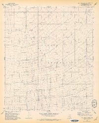
1978 Map of San Ignacio Ranch
USGS Topo · Published 1979About this map
Aguirre Valley and its vast drainage network define this desert landscape within the Papago Indian Reservation. The 1970s terrain is characterized by the prominent Aguirre Wash, which weaves through the center of the sheet, reflecting the vital role of seasonal water flow in the Pima County desert. The focal point of human activity is the San Ignacio Ranch, a localized hub featuring several Corrals and a Well, indicating the enduring presence of ranching operations in this arid environment. A small, unnamed Cem is located south of the main ranch buildings, offering a specific point of interest for genealogists and local historians tracing the settlement patterns of this remote ranching area.
Find a feature on this map
7 named features on this map. Tap any name to fly to it.
Don’t see what you’re looking for? This feature index may not catch every label — zoom into the map to look around manually.
Map Details
Editions of this 1978 San Ignacio Ranch Map
This is the sole edition of this map. No revisions or reprints were ever made.
Other maps of this area

1934 · Tucson Mountains
USGS Topo · 1:125,000

1934 · Silver Bell
USGS Topo · 1:125,000

1938 · San Vicente
USGS Topo · 1:62,500

1941 · San Vicente
USGS Topo · 1:62,500

1941 · Cocoraque Butte
USGS Topo · 1:62,500

1942 · San Vicente
USGS Topo · 1:62,500

1943 · Cocoraque Butte
USGS Topo · 1:62,500

1948 · San Vicente
USGS Topo · 1:62,500

1956 · Tucson
USGS Topo · 1:250,000

1958 · Tucson
USGS Topo · 1:250,000