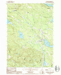
1987 Map of Sanbornville
USGS Topo · Published 1987About this map
The village of Sanbornville serves as a focal point in this eastern New Hampshire landscape, where the local economy and geography were historically shaped by rail and water. The map records the dual identities of settlements like East Wakefield (Burleyville Station) and East Wolfeboro (Cotton Valley Station), indicating the persistent legacy of the railroad in defining these communities. To the west, the Governor Wentworth State Farm occupies the land near Lake Wentworth, while the rugged peaks of the Moose Mountains and Copple Crown Mtn dominate the southern topography. Significant water bodies, including Lovell Lake and Kingswood Lake, are surrounded by smaller developments and scattered cemeteries, offering a detailed view of late-20th-century land use in Wakefield and Brookfield. The transition from the wetland Union Meadows to the high elevations of Phoebes Nable Mtn illustrates the varied terrain of the Carroll and Strafford county border.
Find a feature on this map
55 named features on this map. Tap any name to fly to it.
Don’t see what you’re looking for? This feature index may not catch every label — zoom into the map to look around manually.
Map Details
Editions of this 1987 Sanbornville Map
This is the sole edition of this map. No revisions or reprints were ever made.
Other maps of this area

1891 · Berwick
USGS Topo · 1:62,500

1891 · Newfield
USGS Topo · 1:62,500

1893 · Berwick
USGS Topo · 1:62,500

1893 · Newfield
USGS Topo · 1:62,500

1919 · Alton
USGS Topo · 1:62,500

1928 · Wolfeboro
USGS Topo · 1:62,500

1933 · Berwick
USGS Topo · 1:48,000

1933 · Newfield
USGS Topo · 1:48,000

1937 · Newfield
USGS Topo · 1:62,500

1937 · Berwick
USGS Topo · 1:62,500