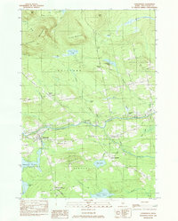
1984 Map of Sangerville
USGS Topo · Published 1984About this map
The Piscataquis River winds through this mid-1980s portrait of central Maine, serving as the historical and geographic anchor for the neighboring towns of Sangerville, Guilford, and Dover-Foxcroft. The landscape is a transition between the industrial river corridor and the high ground of Guilford Mountain and Buker Mountain. Evidence of the region's earlier transportation network is visible in the Old Railroad Grade and the iconic Lows Bridge spanning the river. Local genealogy and land use are well-documented through small family or community clusters like Howard Corner and Jackson Corner, alongside several burial sites including Rural Grove Cem and Brawn Cem. While the river remains central, the interior is dotted with significant water bodies such as Salmon Stream Pond and Manhanock Pond, reflecting the rural character of Piscataquis County during this era.
Find a feature on this map
59 named features on this map. Tap any name to fly to it.
Don’t see what you’re looking for? This feature index may not catch every label — zoom into the map to look around manually.
Map Details
Editions of this 1984 Sangerville Map
This is the sole edition of this map. No revisions or reprints were ever made.
Other maps of this area

1932 · Dover-Foxcroft
USGS Topo · 1:48,000

1933 · Guilford
USGS Topo · 1:62,500

1935 · Dover-Foxcroft
USGS Topo · 1:62,500

1937 · Guilford
USGS Topo · 1:62,500

1940 · Sebec
USGS Topo · 1:48,000

1943 · Sebec
USGS Topo · 1:62,500

1950 · Sebec Lake
USGS Topo · 1:62,500

1954 · Millinocket
USGS Topo · 1:250,000

1958 · Millinocket
USGS Topo · 1:250,000

1960 · Millinocket
USGS Topo · 1:250,000