
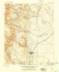
1889 Map of Santa Fe
USGS Topo · Published 1963About this map
Santa Fe serves as the focal point of this late 19th-century landscape, appearing at a transitional moment before the arrival of the modern automobile era. The territorial capital is anchored by the presence of Old Fort Marcy and connected to the wider world by the Santa Fe Southern R. R. and the Atchison Topeka and Santa Fe Railroad, which snakes through the challenging terrain of Apache Canyon. This survey captures the distinct cultural geography of northern New Mexico, from the established Tesuque Pueblo to small settlements like Rodriguez and Gonzales Ranch.
Find a feature on this map
59 named features on this map. Tap any name to fly to it.
Don’t see what you’re looking for? This feature index may not catch every label — zoom into the map to look around manually.
Map Details
Editions of this 1889 Santa Fe Map
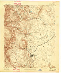
This is the sole edition of this map. No revisions or reprints were ever made.
Other maps of this area
1889 · Las Vegas
USGS Topo · 1:125,000

1890 · Bernal
USGS Topo · 1:125,000

1891 · Bernal
USGS Topo · 1:125,000

1891 · Las Vegas
USGS Topo · 1:125,000

1892 · San Pedro
USGS Topo · 1:125,000

1892 · Santa Clara
USGS Topo · 1:125,000
1893 · Las Vegas
USGS Topo · 1:125,000

1894 · Santa Fe
USGS Topo · 1:125,000
1894 · Bernal
USGS Topo · 1:125,000

1894 · Lamy
USGS Topo · 1:125,000