
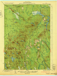
1975 Map of Saponac SE
USGS Topo · Published 1980This historical map portrays the area of Saponac SE in 1975, primarily covering Great Pond as well as portions of T39 MD BPP, Grand Falls Township, and T3 ND BPP. Featuring a scale of 1:24,000, this map provides a highly detailed snapshot of the terrain, roads, buildings, counties, and historical landmarks in the Saponac SE region at the time. Published in 1980, it is the sole known edition of this map.
Map Details
Editions of this 1975 Saponac SE Map
This is the sole edition of this map. No revisions or reprints were ever made.
Other maps of this area

1929 · Great Pond
USGS Topo · 1:48,000

1929 · Lead Mountain
USGS Topo · 1:48,000

1931 · Saponac
USGS Topo · 1:48,000

1932 · Nicatous Lake
USGS Topo · 1:48,000

1932 · Lead Mountain
USGS Topo · 1:62,500
1932 · Great Pond
USGS Topo · 1:62,500
1934 · Saponac
USGS Topo · 1:62,500

1934 · Nicatous Lake
USGS Topo · 1:62,500

1948 · Bangor
USGS Topo · 1:250,000

1954 · Millinocket
USGS Topo · 1:250,000