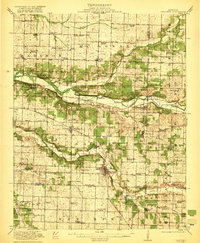
1921 Map of Sarcoxie
USGS Topo · Published 1921About this map
Sarcoxie serves as the focal point of this southwestern Missouri landscape during the early 1920s, situated at the intersection of the St Louis San Francisco railroad and the Center Creek valley. The map reveals a highly developed rural infrastructure defined by an exceptional density of country schools and community landmarks. Local industry is anchored by the Red Fox Mine and a Limekiln near the town center, while water-powered commerce persists at Bower Mills and Hopsick Mill.
Find a feature on this map
93 named features on this map. Tap any name to fly to it.
Don’t see what you’re looking for? This feature index may not catch every label — zoom into the map to look around manually.
Map Details
Editions of this 1921 Sarcoxie Map
2 editions found
Other maps of this area

1886 · Greenfield
USGS Topo · 1:125,000

1886 · Carthage
USGS Topo · 1:125,000

1888 · Greenfield
USGS Topo · 1:125,000

1894 · Carthage
USGS Topo · 1:125,000

1916 · Neosho
USGS Topo · 1:62,500

1921 · Stotts City
USGS Topo · 1:62,500

1921 · Sarcoxie
USGS Topo · 1:62,500

1943 · Ritchey
USGS Topo · 1:62,500

1943 · Monett
USGS Topo · 1:62,500

1945 · Harrison
USGS Topo · 1:250,000