1978 Map of Sardis
USGS Topo · Published 1978About this map
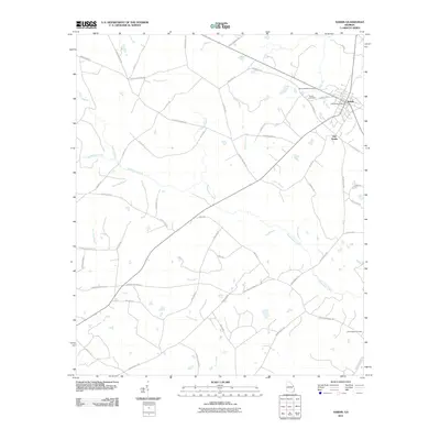
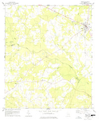
Sardis serves as the primary hub in this corner of Burke County during the late 1970s, situated near the intersection of several regional routes. The landscape is defined by the winding course of Beaverdam Creek and its many tributaries, including Lovett Branch and Dry Branch, which carve through the agricultural terrain. For genealogists, the map is particularly detailed regarding local congregations and burial grounds, showing the spatial relationship between New McCoy Ch, Old McCoy Ch, and Dry Branch Ch. This survey was compiled from aerial photography taken in 1972 and field checked in 1974, capturing the rural character of the region just before significant modern changes. The triple-county boundary where Burke, Jenkins, and Screven meet is clearly marked in the southeast, near Ellis Chapel and Horse Creek.
Find a feature on this map
22 named features on this map. Tap any name to fly to it.
Don’t see what you’re looking for? This feature index may not catch every label — zoom into the map to look around manually.
Map Details
Editions of this 1978 Sardis Map
This is the sole edition of this map. No revisions or reprints were ever made.
Historical Maps of Sardis Through Time
6 maps found