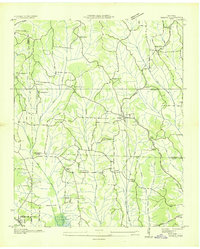
1936 Map of Sardis
USGS Topo · Published 1936About this map
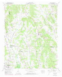
Sardis serves as a central hub in this rural landscape of West Tennessee, where numerous small communities and family landmarks define the social fabric during the mid-1930s. The map illustrates a dense network of country schools and churches, including Wakeforest Sch, Union Hill Sch, and Little Hurricane Ch, which were the cornerstones of local life. The terrain is deeply carved by water, with the Middle Fork Doe Creek and Hurricane Creek winding through the valleys. The infrastructure reflects a period of modernization as the Tennessee Electric Power Company Transmission Line cuts across the eastern side of the quadrangle. Significant for genealogists, the map identifies specific family-linked sites such as Taylors Store and Mc Bride Cem, while the irregular county boundaries of Henderson, Chester, McNairy, and Hardin counties converge in this complex rural intersection.
Find a feature on this map
41 named features on this map. Tap any name to fly to it.
Don’t see what you’re looking for? This feature index may not catch every label — zoom into the map to look around manually.
Map Details
Editions of this 1936 Sardis Map
This is the sole edition of this map. No revisions or reprints were ever made.
Historical Maps of Sardis Through Time
7 maps found