
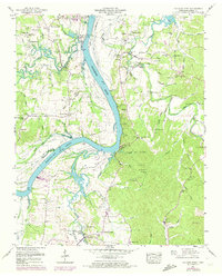
1949 Map of Hookers Bend
USGS Topo · Published 1952About this map
Kentucky Lake and the Tennessee River dominate this 1940s landscape, illustrating the hydrological changes brought by the Tennessee Valley Authority. Small riverboat and ferry points such as Farmers Union Landing, Cravens Landing, and Bickey Landing are documented along the banks, marking the historic reliance on water transport in Hardin County. The interior is characterized by a network of family-named cemeteries and rural institutions, including the Anderson Cem, McCandless Cem, and Oak Grove Sch.
Find a feature on this map
88 named features on this map. Tap any name to fly to it.
Don’t see what you’re looking for? This feature index may not catch every label — zoom into the map to look around manually.
Map Details
Editions of this 1949 Hookers Bend Map
2 editions found
Other maps of this area

1936 · Savannah
USGS Topo · 1:24,000

1936 · Wolf Pit Ridge
USGS Topo · 1:24,000

1936 · Hookers Bend
USGS Topo · 1:24,000

1936 · Thurman
USGS Topo · 1:24,000

1936 · Olivehill
USGS Topo · 1:24,000

1936 · Bath Springs
USGS Topo · 1:24,000

1936 · Sardis
USGS Topo · 1:24,000

1936 · Milledgeville
USGS Topo · 1:24,000

1936 · Pittsburg Landing
USGS Topo · 1:24,000
1949 · Bath Springs
USGS Topo · 1:24,000