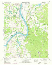
1949 Map of Hookers Bend
USGS Topo · Published 1974About this map
Tennessee River commerce and the expanding waters of Kentucky Lake dominate this Hardin County landscape, where riverfront landings once served as the primary hubs for local trade. Historical points like Farmers Union Landing and Dickey Landing mark the old riverbank, while the settlement of Saltillo sits at the northern edge of this reach. The map captures a transition in the valley's rural life, showing established communities like Cerro Gordo alongside numerous family landmarks and rural institutions, including the Cerro Gordo Sch and Hobbs Mill.
Find a feature on this map
97 named features on this map. Tap any name to fly to it.
Don’t see what you’re looking for? This feature index may not catch every label — zoom into the map to look around manually.
Map Details
Editions of this 1949 Hookers Bend Map
2 editions found
Other maps of this area

1936 · Savannah
USGS Topo · 1:24,000

1936 · Wolf Pit Ridge
USGS Topo · 1:24,000

1936 · Hookers Bend
USGS Topo · 1:24,000

1936 · Thurman
USGS Topo · 1:24,000

1936 · Olivehill
USGS Topo · 1:24,000

1936 · Bath Springs
USGS Topo · 1:24,000

1936 · Sardis
USGS Topo · 1:24,000

1936 · Milledgeville
USGS Topo · 1:24,000

1936 · Pittsburg Landing
USGS Topo · 1:24,000

1949 · Hookers Bend
USGS Topo · 1:24,000