
1936 Map of Olivehill
USGS Topo · Published 1936About this map
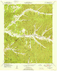
Hardin Creek and Indian Creek dominate this 1936 landscape, a region defined by intricate drainage networks and ridge-top settlements in the Tennessee Valley. The community of Olivehill serves as a central hub, situated near the Arch Bridge Company along Highway No 64. This era shows a dense distribution of rural infrastructure, including Havana Sch, Rose Sch, and Bethlehem Sch, illustrating the dispersed nature of local education before school consolidation. Religious and social life is anchored by Mt Carmel Ch, Perry Chapel, and the Piney Grove cemetery. The terrain is marked by family-named landmarks like McCollum Hollow and Baugus Branch, while industrial footprints appear at the Hardin Wayne Gravel Pit. Local transit relied on numerous crossings like the Sandy Bottom Island area, reflecting a time when geography dictated the flow of commerce and community connection.
Find a feature on this map
142 named features on this map. Tap any name to fly to it.
Don’t see what you’re looking for? This feature index may not catch every label — zoom into the map to look around manually.
Map Details
Editions of this 1936 Olivehill Map
This is the sole edition of this map. No revisions or reprints were ever made.
Other maps of this area

1905 · Waynesboro
USGS Topo · 1:125,000

1936 · Savannah
USGS Topo · 1:24,000

1936 · Wolf Pit Ridge
USGS Topo · 1:24,000

1936 · Hookers Bend
USGS Topo · 1:24,000

1936 · Eagle Creek
USGS Topo · 1:24,000

1936 · Thurman
USGS Topo · 1:24,000

1936 · Bath Springs
USGS Topo · 1:24,000

1936 · Clifton
USGS Topo · 1:24,000

1936 · Martins Mills
USGS Topo · 1:24,000
1949 · Eagle Creek
USGS Topo · 1:24,000