
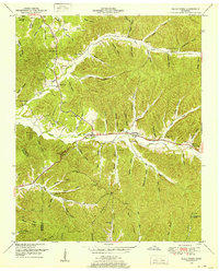
1936 Map of Eagle Creek
USGS Topo · Published 1936About this map
The borderlands of Wayne and Hardin Counties are defined here by the winding course of Eagle Creek and the intricate network of hollows that feed into it. During this mid-1930s survey, the area maintained a rural structure anchored by small community centers like Evans Chapel and the Philadelphia Ch and Philadelphia Sch complex. The landscape is marked by numerous family-named landmarks such as Roberts Hollow, Shipman Hollow, and Dillion Hollow, indicating long-established settlement patterns in these drainage basins. Modern infrastructure is represented by the State Transmission Line and U S Highway No 64, which bisect the terrain. Genealogists may find interest in the scattered burial grounds, including the Lizard Glade Cem and Griggs Cem, while the location of Old Mill Spring points to historical water-powered industry along the eastern creek branches.
Find a feature on this map
78 named features on this map. Tap any name to fly to it.
Don’t see what you’re looking for? This feature index may not catch every label — zoom into the map to look around manually.
Map Details
Editions of this 1936 Eagle Creek Map
This is the sole edition of this map. No revisions or reprints were ever made.
Other maps of this area

1905 · Waynesboro
USGS Topo · 1:125,000

1936 · Wolf Pit Ridge
USGS Topo · 1:24,000

1936 · Olivehill
USGS Topo · 1:24,000

1936 · Bath Springs
USGS Topo · 1:24,000

1936 · Leatherwood
USGS Topo · 1:24,000

1936 · Clifton
USGS Topo · 1:24,000

1936 · Three Churches
USGS Topo · 1:24,000

1936 · Waynesboro
USGS Topo · 1:24,000

1936 · Martins Mills
USGS Topo · 1:24,000
1949 · Eagle Creek
USGS Topo · 1:24,000