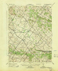
1943 Map of Sassamansville
USGS Topo · Published 1943About this map
Ringing Rock Park sits at the southwestern edge of this Montgomery County landscape, as documented by the War Department during the early 1940s. The region is defined by a dense network of small crossroads settlements and farming communities, including Sassamansville, Gilbertsville, and Frederick. The land is intricately drained by numerous waterways such as West Swamp Creek, Minister Creek, and the Northwest Branch Perkiomen Creek, which carve through the townships of Douglass, New Hanover, and Upper Hanover.
Find a feature on this map
34 named features on this map. Tap any name to fly to it.
Don’t see what you’re looking for? This feature index may not catch every label — zoom into the map to look around manually.
Map Details
Editions of this 1943 Sassamansville Map
This is the sole edition of this map. No revisions or reprints were ever made.
Other maps of this area

1888 · Quakertown
USGS Topo · 1:62,500

1890 · Quakertown
USGS Topo · 1:62,500

1894 · Quakertown
USGS Topo · 1:62,500

1894 · Norristown
USGS Topo · 1:62,500

1895 · Norristown
USGS Topo · 1:62,500

1896 · Norristown
USGS Topo · 1:62,500

1902 · Boyertown
USGS Topo · 1:62,500

1906 · Phoenixville
USGS Topo · 1:62,500

1942 · Norristown
USGS Topo · 1:125,000

1943 · Manatawny
USGS Topo · 1:31,680
Featured Places
- Pottstown, PA
- Limerick Township, PA
- New Hanover Township, PA
- Gilbertsville, Douglass Township
- Bechtelsville, PA