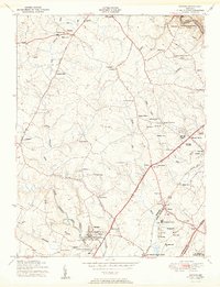
1950 Map of Savage
USGS Topo · Published 1950About this map
The Little Patuxent River and Middle Patuxent River carve through this central Maryland landscape, defining the character of communities like Savage and Guilford at mid-century. This survey captures a specific era of institutional and infrastructure development in Howard and Anne Arundel counties, evidenced by the presence of the Maryland House of Correction, a Womens prison, and the FCC Monitoring Station. The map illustrates a rural landscape transitioning toward modernity, where the Baltimore and Ohio railroad and the Baltimore-Washington Express Highway intersect a network of older settlements such as Oakland Mills, Jonestown, and Waterloo. Local history is deeply etched into the terrain through numerous spiritual and educational landmarks, from St Marys College and Trinity Preparatory School to the Rosa Bonheur Pet Cemetery. The Laurel Harness Racing Track near the southern boundary further highlights the varied land use of the period.
Find a feature on this map
67 named features on this map. Tap any name to fly to it.
Don’t see what you’re looking for? This feature index may not catch every label — zoom into the map to look around manually.
Map Details
Editions of this 1950 Savage Map
2 editions found
Other maps of this area

1892 · Laurel
USGS Topo · 1:62,500

1892 · Ellicott
USGS Topo · 1:62,500

1894 · Ellicott
USGS Topo · 1:62,500

1894 · Laurel
USGS Topo · 1:62,500

1894 · Baltimore
USGS Topo · 1:62,500

1894 · Relay
USGS Topo · 1:62,500

1897 · Laurel
USGS Topo · 1:62,500

1899 · Baltimore
USGS Topo · 1:62,500

1904 · Baltimore
USGS Topo · 1:62,500

1906 · Ellicott
USGS Topo · 1:62,500