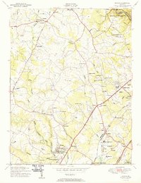
1950 Map of Savage
USGS Topo · Published 1950About this map
The Little Patuxent River winds through this mid-century landscape, anchoring the mill town of Savage and the early developments of Columbia. At this time, the region is a patchwork of rural holdings and institutional grounds, including the Maryland House of Correction and a Womens prison near Jessup. Notable landmarks like the Laurel Harness Racing Track and the FCC Monitoring Station reflect the diverse uses of the land before the massive suburban expansion of later decades.
Find a feature on this map
67 named features on this map. Tap any name to fly to it.
Don’t see what you’re looking for? This feature index may not catch every label — zoom into the map to look around manually.
Map Details
Editions of this 1950 Savage Map
2 editions found
Other maps of this area

1892 · Laurel
USGS Topo · 1:62,500

1892 · Ellicott
USGS Topo · 1:62,500

1894 · Ellicott
USGS Topo · 1:62,500

1894 · Laurel
USGS Topo · 1:62,500

1894 · Baltimore
USGS Topo · 1:62,500

1894 · Relay
USGS Topo · 1:62,500

1897 · Laurel
USGS Topo · 1:62,500

1899 · Baltimore
USGS Topo · 1:62,500

1904 · Baltimore
USGS Topo · 1:62,500

1906 · Ellicott
USGS Topo · 1:62,500