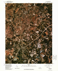
1981 Map of Savage
USGS Topo · Published 1986About this map
The developing planned community of Columbia stands out as a sprawling network of suburban cul-de-sacs and commercial centers in this 1981 orthophotoquad. This aerial perspective, captured via color infrared photography, reveals the rapid transformation of the Howard County landscape from rural farmland to a major residential and industrial hub. The image clearly traces the paths of the Little Patuxent River and Middle Patuxent River as they wind through the burgeoning town, providing a sharp contrast between the organic curves of the waterways and the engineered grids of new development. To the east and south, the older settlements of Waterloo, Jessup, and Savage appear amidst a mix of wooded areas and large-scale industrial sites, linked by the prominent corridor of the Baltimore Washington Parkway. The map also captures a small portion of the Patapsco River in the northeastern corner, marking the regional boundary.
Find a feature on this map
8 named features on this map. Tap any name to fly to it.
Don’t see what you’re looking for? This feature index may not catch every label — zoom into the map to look around manually.
Map Details
Editions of this 1981 Savage Map
This is the sole edition of this map. No revisions or reprints were ever made.
Other maps of this area

1892 · Laurel
USGS Topo · 1:62,500

1892 · Ellicott
USGS Topo · 1:62,500

1894 · Ellicott
USGS Topo · 1:62,500

1894 · Laurel
USGS Topo · 1:62,500

1894 · Baltimore
USGS Topo · 1:62,500

1894 · Relay
USGS Topo · 1:62,500

1897 · Laurel
USGS Topo · 1:62,500

1899 · Baltimore
USGS Topo · 1:62,500

1904 · Baltimore
USGS Topo · 1:62,500

1906 · Ellicott
USGS Topo · 1:62,500